GREEN TRAVEL
Fuji Ride · 3-Day Animated Route
10/24–10/26 | Custom route v3.3 candidate (updated 2026-09-11 after two Codex reviews) | 10/25 goes to Hakone to avoid the official event | Not yet confirmed by the Japanese partners; not official navigation
· All language versions
Daily Schedule
| Day | Start point & time | Lunch stop | Destination & ETA | Ride | Hotel |
|---|---|---|---|---|---|
| Day 1Fri 10/23 | Haneda Airport, depending on each flight | — | Coach pickup → hotel | No riding | Fuji Premium Resort |
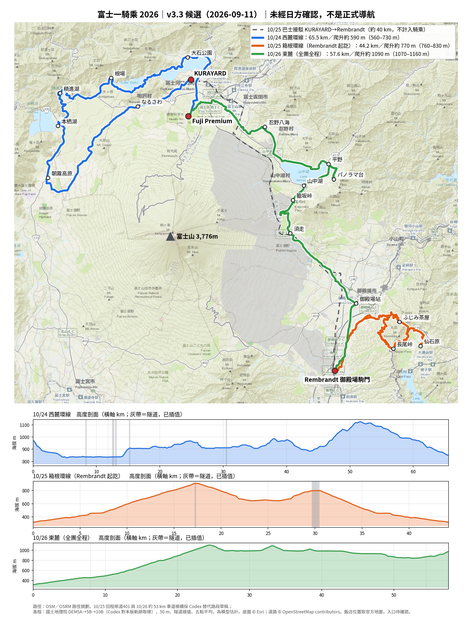
| Day 2Sat 10/24 | Fuji Premium Resort 08:00 start bikes handed over at the hotel · support van follows | Michi-no-Eki Asagiri Kogen (at about 42.6 km) | KURAYARD approx. 14:30–16:00 | West Loop 65.5 km · climb ≈ 590 m Oishi Park · Saiko Iyashi-no-Sato · Lake Shoji · Lake Motosu | KURAYARD (whole house) (riders who don't fit stay at a nearby hotel) |
| Day 3Sun 10/25 | Support van leaves KURAYARD before 08:00 (about 40 km) All riders and bikes ready at Rembrandt, 09:30 start | Sengokuhara (at about 24.7 km) | Rembrandt (loop, same start & finish) approx. 14:30–16:00 Sunset 16:58 | Hakone Loop 44.2 km · climb ≈ 770 m Nagao Pass · Sengokuhara pampas grass · Otome Pass (Fujimi Chaya) | Rembrandt Style Gotemba Komakado |
| Day 4Mon 10/26 | Rembrandt 08:00 start support van follows | Oshino Hakkai (at about 46.1 km) | Fuji Premium Resort approx. 14:30–16:00 bikes returned at Kawaguchiko | East side, full ride 57.6 km · climb ≈ 1,090 m Kagosaka Pass · Lake Yamanaka · Panorama-dai (optional) | Fuji Premium Resort |
| Day 5Tue 10/27 | Fuji Premium Resort | — | Coach departs 10:00 → Narita Airport | No riding | — |
A support van follows the group on all three riding days: hop in whenever you need a rest, and the supplies ride with it. Large luggage stays at Fuji Premium (the first and last nights are at the same hotel); only an overnight bag travels with the van. The 27-seat coach only handles airport transfers. Bikes are handed over at Fuji Premium on 10/24 and returned at Kawaguchiko on 10/26 — 14 in total (6 road, 7 flat-bar, 1 e-bike). Times are planning estimates for an average 12–15 km/h, with time added for sightseeing, lunch and regrouping; they still need confirmation from the Japanese partners and the bike shop. The whole group rides the same route together.
Hotels, transfers & timing
- 10/23 · 10/26🏠 Fuji Premium Resort (south shore of Lake Kawaguchi, Kodachi) | 10/24 start · 10/26 finish; large luggage stays here for the whole trip
- 10/24🏠 KURAYARD, whole house rental (Kodachi, Lake Kawaguchi; booked by Paul) | riders who don't fit stay at other hotels
- 10/25🏠 Rembrandt Style Gotemba Komakado (next to Komakado PA) | 10/25 start & finish · 10/26 start
- 🚐 Support vanThree support vans (two 10-seat Hiace, one Alphard with a roof rack, from Shoryu Travel, with three staff and supplies), with the group for all three days, 10/24–10/26; hop in for a rest whenever you need, and they carry the overnight bags
- 🚌 CoachThe 27-seat coach only does the 10/23 Haneda pickup and the 10/27 departure from the hotel at 10:00 for Narita Airport; it does not follow the rides
- 🚲 BikesHanded over at Fuji Premium on 10/24 and returned at Kawaguchiko on 10/26; 14 bikes in total (6 road, 7 flat-bar, 1 e-bike), supplied by Chien-liang's club and a Kawaguchiko bike shop, with coaches riding along
- 🚐 10/25Support van leaves KURAYARD before 08:00, heading for Rembrandt, about 40 km (roughly 45–75 min, planning estimate). Goal: all riders and all 14 bikes ready to leave Rembrandt around 09:30; people, bikes and luggage share the vans, so space is tight — pack light
- 🌇 10/25Sunset in Gotemba 16:58 (NAOJ calculation). A sightseeing ride is estimated at 5–6.5 hours; aim to be back at the hotel before 16:00. Starting at 11:00 leaves too little margin (middle scenario: back at the hotel around 16:50)
Meals: breakfast at the hotels, lunch on your own along the route; all dinners are booked — the hotel on 10/23, in-house at KURAYARD on 10/24, the Driftwood omakase restaurant on 10/25, and Sanrokuen on 10/26 (paid individually). Hotel start and finish points use the official map locations; the actual bike handover and parking entrances are still to be confirmed. Transfers are not counted in riding distance or climbing.
Version & items to confirm
- Statusv3.3 candidate, not yet confirmed rideable by the Japanese partners or the bike shop, no approval from road authorities, not surveyed on site
- Fixed10/25 return now uses Pref. Road 401, avoiding the 100 m tunnel on the Gotemba Bypass and an ~11 m turnaround against a one-way street; 10/26 around 53 km now uses regular roads (including Route 139) instead of a short sidewalk bridge; the ~8 m sandy out-and-back at Oshino Hakkai was removed
- Walk if needed10/26 signalized crossing at Lake Yamanaka and ~4 m of gravel in a parking lot; ~1.2 km shared bike/foot path at Lake Yamanaka — give way to pedestrians
- Short steep bits10/25 narrow road toward Otome after the Susuki grassland turnaround, DEM estimate ~14% over 200 m; 10/26 ~9% just before the hotel (terrain-data estimates, not measured)
- To confirm with JapanTurns, shoulders, traffic and 14-bike group handling on the Pref. Road 401 return and the Route 139 section at 53 km; lighting and roadworks in the Otome and Nagao tunnels on the day; hotel meeting/loading/bike-handover entrances; a few junctions that differ on the latest map
- To confirmLunch restaurants and seating for 17; whether Fujimi Chaya and Michi-no-Eki Subashiri are open that day; whether there is an event at Michi-no-Eki Narusawa on 10/24 (not on the village's 2026 calendar)
Downloads (v3.3 candidate)
- MapRoute map + elevation profile .jpg
- 10/24West Loop | riding only .gpx
- 10/25Hakone Loop | riding only .gpx
- 10/26East side full | riding only .gpx
- Transfer10/25 bus | vehicle only .gpx
"Riding only" files contain just the bike track and can be imported into Strava, RideWithGPS or YAMAP; don't use the vehicle file for riding navigation. Files have no elevation data; watch for waypoints marked "walk if needed", "steep" and "traffic to confirm". This is a candidate route, not yet confirmed by the Japanese partners and not official navigation approved by road authorities; it may change before the trip.
Revision history
- Itinerary details updated2026-10-21 · route and GPX unchangedUpdated from the LINE group and Shoryu Travel's support-van itinerary (10/19): 14 bikes in total (6 road, 7 flat-bar, 1 e-bike), handed over at Fuji Premium on 10/24 and returned at Kawaguchiko on 10/26; the 10/24, 10/25 and 10/26 dinners are all booked; the daily highlights are now listed (Oishi Park, Lake Shoji, Lake Motosu, Nagao Pass, Sengokuhara pampas grass, Otome Pass, Panorama-dai); on 10/27 the coach leaves the hotel at 10:00 for Narita.
- Itinerary update2026-09-19 · route and GPX unchangedUpdated from the travel agency's latest itinerary and the vehicle arrangements in Japan: three support vans now follow the group on all three riding days (hop in for a rest; they carry supplies and overnight bags); the 27-seat coach only handles the 10/23 Haneda pickup, the 10/27 Narita drop-off and the bike pickup and return; bikes are now returned at the hotel on 10/27; large luggage stays at Fuji Premium throughout.
- Page update2026-09-11 · route and GPX unchangedAdded a daily schedule (start point and time, lunch stop, destination and ETA, hotel for each day) and English, Japanese and Simplified Chinese versions of this page.
- v3.3 candidate2026-09-11 · current versionSame route as v3.2; passed Codex's second review. Climbing recalculated on this version's track (about 167 km and 2,450 m of climbing over three days), distance markers for the re-routed sections corrected, and two GPX reminders added: "give way to pedestrians on the bike path" and "Route 139 traffic to be confirmed".
- v3.2 candidate2026-09-11Route changes after Codex's independent review: the 10/25 return now uses Pref. Road 401, avoiding a 100 m tunnel of unclear bicycle access and a short wrong-way section; 10/26 around 53 km uses regular roads instead of a pedestrian bridge; the sandy lane next to the Oshino Hakkai meeting point was dropped. Added reminders for short steep sections (10/25 ~14%, 10/26 ~9%) and the 10/25 timing: all riders and bikes ready at 09:30, sunset 16:58. 10/25 shortened from 44.9 km to 44.2 km.
- v3.12026-09-11Fixes after Codex's first review: start and finish moved to the hotels' actual locations; a forest-road section in Hakone re-routed; climbing recalculated with GSI terrain data; GPX split into "riding only" and "vehicle only" files. Later the same day, 10/26 changed to the whole group riding the full route from Rembrandt, dropping the A/B groups and the Subashiri shuttle.
- v32026-09-11Three days re-planned, removing sections that are footpaths or forest roads on the map. On 10/25 the Otome forest-road spur was dropped in favor of a stop at Fujimi Chaya on Otome Pass to see Mt. Fuji; the main route now follows the paved "Nagao Pass Panorama" route from a professional route platform. The trip is about scenery and quality, not racing.
- v22026-09-10First animated route: stay at KURAYARD on 10/24 and ride Hakone on 10/25 to avoid the official event. Checks later found some footpath and forest-road sections and inaccurate hotel locations; this version is no longer provided.
Every version is still a candidate route, not yet confirmed rideable by the Japanese partners or the bike shop, and not official navigation approved by road authorities. Distances and climbing are estimates from map and terrain data.
Review log & sources (v3.3 candidate, 2026-09-11)
Version flow: v3.1 → Codex independent review → v3.2 candidate (re-routed) → Codex light review (file integrity, splicing, distance, climbing and OSM tags on the new sections all PASS) → this v3.3 candidate: riding coordinates identical to v3.2, distance markers for the replaced sections corrected, climbing recalculated from elevation sampled directly on this track by Codex, and reminder waypoints added.
| Route | Riding distance | Total climb (main setting) | Range across settings |
|---|---|---|---|
| 10/24 West | 65.5 km | ≈ 590 m | 560–730 m |
| 10/25 Hakone (return via Pref. Rd 401) | 44.2 km | ≈ 770 m | 760–830 m |
| 10/26 East side (whole group, full ride) | 57.6 km | ≈ 1,090 m | 1,070–1,160 m |
Three-day total about 167 km and 2,450 m of climbing (exact: 167.31 km / 2,450.11 m; everyone rides the same route, no groups). Transfers extra: 10/25 bus about 40 km.
Main climbs vs. Fengguizui: Pref. Rd 401 junction to Nagao Pass about 7.51 km, net gain about 323 m, average about 4.3%, steepest 200 m about 6.4% (plus a 1.49 km, ~80 m, 5.3% lead-in on Route 138). Fengguizui (Taipei) from Fenglin Bridge to the pavilion is about 6.4 km, 420 m, 6.3% (source). The long climb is gentler on average than Fengguizui but lasts longer; including the lead-in it is about 9 km and 400 m of continuous climbing, close to one Fengguizui.There are also short steep bits: 10/25 the narrow road toward Otome after the Susuki grassland turnaround (about 27.46–27.66 km), DEM estimate ~13.9% over 200 m; 10/26 about 57.07–57.27 km just before the hotel, ~9.1%. On 10/26 it is about 24 km and 790 m of climbing from the hotel to Kagosaka Pass, including Subashiri to Kagosaka Pass at about 5.94 km, 285 m, 4.8%. All are terrain-data estimates, not measured grades; e-bike riders should save battery, the group rides at the slowest rider's pace, and time is reserved for breaks or walking.
Method: routes planned with OSM/OSRM; 10/25 return 35.511–36.626 km (cumulative distance on this GPX, replacing 35.511–37.378 km in v3.1) and 10/26 52.973–53.441 km use Codex's replacement sections spliced into the full-day tracks; coordinates and this GPX's cumulative distance are authoritative for km markers. Elevation is GSI DEM5A→5B→10B sampled every 50 m directly on this track by Codex, with linear interpolation through tunnels plus 50 m at each portal, smoothing radius 0–3, main setting a 5-point moving average; Claude recalculated with the same method and matches Codex. Figures are model estimates, not measurements.
Road items: v3.1's wrong-way turnaround on a one-way road (way 148860149) and the 100 m Gotemba Bypass tunnel (way 148860099) are no longer on the route; the 10/26 sidewalk/bridge ways 1422819140, 1422819141 and 1422819145 no longer overlap (the previously listed 946193644 was not on the route, and 1422819126 was not actually used). New sections: Pref. Rd 401 (way 28697413, secondary) and the 10/26 roads (99194221 → 40796641 → 110252857 → 110252453 → 1556700438, the last three on Route 139) currently carry no oneway, footway, bicycle/access prohibition or motorroad tags in OSM — this is a reading of map tags, not a permit from road authorities, and does not mean it is confirmed rideable; turns, shoulders, traffic and group handling are to be confirmed by the Japanese partners. The Otome Tunnel (825 m) is supported by Gotemba City's official cycling guide; conditions on the day are to be confirmed. Lake Yamanaka signalized crossing (way 1236402561) and ~4 m gravel (way 978936834): walk if needed; shared path way 576296045 (bicycle=designated, foot=designated): give way to pedestrians. 10/24 Nagasaki Tunnel portals, about 13.2 km and 31.4 km, and 10/26 about 49.4 km are junctions that no longer line up after OSM geometry was redrawn; the on-site road connection is to be confirmed, and this does not mean the route uses sidewalks or prohibited roads.
Hotel location sources: Fuji Premium (Yamanashi Prefecture official tourism page)、Rembrandt official access page. KURAYARD uses the booking coordinates; no public official location was found. Actual meeting, loading and bike-handover entrances are to be confirmed with the hotels. Sunset: NAOJ Ephemeris Computation Office。
GPX file fingerprints (SHA-256, v3.3 candidate)
2026-10-24_西麓環線_v3.3候選_僅騎乘.gpx1c8c18bad6ea6f5c32e025b39ba0f061f6ff42a6c3b71c82c941a5a7c5d9e7822026-10-25_接駁_KURAYARD到Rembrandt_v3.3候選_僅車程.gpx637de638a9704967487e389d193d518cc09f15db4e2e3ae26d284da65b3efbca2026-10-25_箱根環線_v3.3候選_僅騎乘.gpx4fc0aef51ce78ecec26a02f40cc4e8648be610e0eec27266f3d1a6fb256af1f02026-10-26_東麓_全程_v3.3候選_僅騎乘.gpxf27cbe3b5fc5f14803d12bc5242e40e4605bc624f2d174dc6b48a7e3af9e6355
v3.1 and v3.2 files are kept in /downloads/green-travel/fuji-ride-2026/ in their own folders for traceability and are no longer listed as downloads. Road data © OpenStreetMap contributors (ODbL); elevation: Geospatial Information Authority of Japan.